Why Flooding Is Worsening in Kunsela, Ologolo, Gbagada and Other Parts of Lagos
Experts Explain Why Flooding Persists Across Lagos Communities
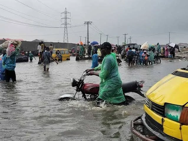
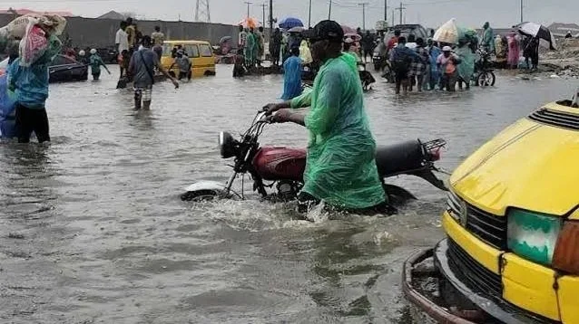
Recurring floods in Kunsela, Ologolo, Gbagada and several other parts of Lagos have renewed concerns about the city's ability to cope with increasingly intense rainfall and rapid urban growth. While heavy downpours continue to trigger flash flooding across the state, urban planning experts, environmental specialists and government officials say the underlying causes extend far beyond seasonal weather patterns.
/ You Might Also Like /
According to experts, decades of unchecked urban expansion, the destruction of wetlands, inadequate flood-control infrastructure and poor land-use planning have significantly reduced Lagos' natural ability to absorb stormwater. Combined with the city's coastal geography and the effects of climate change, these factors continue to increase flood risks across many residential and commercial districts.
Wetland Loss Has Reduced Natural Flood Protection
Urban planning experts identify the widespread conversion of wetlands and mangroves into residential and commercial developments as one of the principal drivers of flooding in Lagos.
Historically, wetlands acted as natural flood buffers by absorbing excess rainfall and gradually releasing water into surrounding waterways. However, rapid development—particularly along the Lekki corridor—has replaced these natural systems with concrete surfaces that generate significantly higher volumes of stormwater runoff. The loss of these ecosystems has also disrupted natural drainage channels and weakened the city's resilience to heavy rainfall.
Environmental experts argue that the continued reclamation of wetlands has prioritised short-term urban development over long-term flood resilience, leaving many communities increasingly vulnerable during the rainy season.
Coastal Geography Compounds Flood Risk
Lagos' physical location also contributes to its persistent flooding challenges.
According to the Lagos State Government, roughly one-third of the state consists of lagoons, rivers, swamps and creeks that serve as the city's primary drainage system. During periods of intense rainfall, particularly when high tides occur simultaneously, stormwater cannot drain efficiently into the Atlantic Ocean and adjoining lagoons. This phenomenon, known as tidal locking, causes water to accumulate in low-lying communities until sea levels recede.
Officials maintain that while flooding cannot be completely eliminated because of Lagos' geography, its impact can be significantly reduced through sustained infrastructure investment and better environmental management.
Urban Growth Has Outpaced Infrastructure
Experts say the city's drainage network has struggled to keep pace with Lagos' rapid population growth and urbanisation.
While drainage expansion remains an important component of flood management, researchers argue that drainage channels alone cannot effectively manage extreme rainfall events. They recommend complementing drainage systems with large-scale stormwater storage infrastructure, including retention reservoirs, underground tunnels and floodwater holding facilities similar to those deployed in cities such as Tokyo and Kuala Lumpur.
Planning professionals also advocate stronger development control, mandatory hydrological assessments for new projects and stricter enforcement against construction on flood-prone land.
Illegal Reclamation and Poor Environmental Practices
Government officials have also linked worsening floods to illegal land reclamation and blocked drainage channels.
The Lagos State Government says unauthorised reclamation activities in areas including Ajiran, Agungi, Ikota and the Chevron corridor have narrowed natural waterways and reduced the capacity of drainage systems. Officials further note that indiscriminate waste disposal continues to block drains and canals, slowing the movement of stormwater during heavy rainfall.
To mitigate the problem, authorities say they have intensified drainage desilting, expanded drainage infrastructure, cleared blocked waterways and issued flood advisories ahead of the peak rainy season.
Experts Call for Long-Term Planning Reforms
Urban planners and environmental specialists agree that addressing Lagos' flooding challenge requires a broader strategy than expanding drainage alone.
Recommendations include protecting remaining wetlands, restoring degraded floodplains, integrating green infrastructure into urban development, strengthening environmental regulations and investing in modern flood-control systems capable of storing excess stormwater during extreme weather events. Experts also emphasise the need for more rigorous planning approvals to prevent further development on ecologically sensitive land.
They argue that combining engineering solutions with nature-based approaches would improve the city's resilience while supporting sustainable urban growth.
Implications for Housing and Urban Development
The recurring floods highlight the growing importance of climate resilience in Nigeria's housing and infrastructure sectors.
For developers, investors and policymakers, the events reinforce the need to incorporate flood-risk assessments into planning decisions, preserve natural drainage systems and prioritise resilient infrastructure in rapidly expanding urban areas. Failure to address these issues could increase construction costs, reduce property values in vulnerable locations and expose communities to repeated economic losses.
Looking Ahead
As Lagos continues to experience rapid urbanisation and more frequent episodes of intense rainfall, experts believe a combination of planning reform, environmental conservation and strategic infrastructure investment will be essential to reducing flood risks. While the city's coastal geography presents permanent challenges, stronger land-use regulation, modern flood-control systems and the protection of natural ecosystems could significantly improve resilience and support more sustainable urban development.
READ MORE