
Communities in Ibeju-Lekki Alarmed by Proposed 150 Metre Coastal Highway Realignment
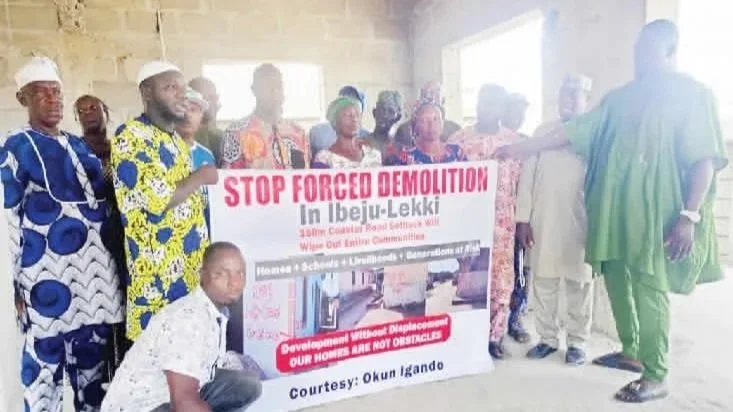
A proposed 150-metre setback enforcement along both sides of the Lagos-Calabar Coastal Highway corridor has triggered concern and anxiety among residents and traditional leaders in Ibeju-Lekki communities in Lagos State. The developments come as fresh markings, allegedly linked to federal planning efforts, prompt fears of renewed property demolitions and displacement.
The Lagos-Calabar Coastal Highway is a flagship federal infrastructure project designed to create a continuous approximately 700-kilometre road link from Lagos in the south-west to Calabar in the south-south, traversing multiple coastal states. While touted by authorities as a transformative regional transport corridor, the project has repeatedly intersected settlements and landholdings, sowing apprehension over compulsory land use and clearance protocols.
Communities Fear Renewed Demolitions and Loss of Homes
Local community leaders told journalists that the 150-metre setback markings representing 150 metres to the right and left of the existing planned road alignment have reignited fears among residents who have already endured earlier phases of demolition and clearance exercises. Many households, some with structures predating the road’s alignment, worry that further enforcement could engulf remaining homes, ancestral sites and cultural landmarks.
Chief Adebayo Agbabiaka and other community representatives described the situation as one of deep anxiety, emphasising the historical and emotional attachment to their land. While acknowledging the broader development goals associated with the coastal highway initiative, they have criticised the apparent lack of clear communication about final route alignments, setback enforcement criteria and compensation frameworks.
One local resident noted that previous compensation packages, reportedly ranging between N9 million and N10 million for affected properties, were insufficient to secure alternative land in the Ibeju-Lekki area a concern that fuels resistance to further land claims.
Official Position and Path Forward
An anonymous source within the Federal Ministry of Works confirmed that the setback markings were carried out by the Office of the Surveyor-General of the Federation. The source stated the exercise was intended to inform local populations about areas considered federal government land adjacent to the coastal route, rather than an immediate demolition order.
Meanwhile, the Zonal Director of Survey Coordination declined to offer an official comment when contacted. The director suggested that inquiries be made during regular government working hours.
Balancing Infrastructure Goals and Community Rights
The tension reflects a broader challenge inherent in large-scale infrastructure development in rapidly urbanising regions: balancing strategic economic and connectivity objectives with the rights, livelihoods and heritage of existing communities. The coast-to-Calabar highway once completed is projected to significantly reduce travel times, stimulate trade and unlock regional economic corridors. Yet, without transparent engagement, these potential benefits are tempered by local grievances and uncertainty.
Community leaders have appealed to both the Federal Ministry of Works and the Lagos State Government to engage in consultative dialogue, clarify setback criteria, and consider waivers or relief mechanisms for long-standing settlements. Their requests reflect a desire for predictable planning outcomes and protection against unilateral land loss.
The proposed 150-metre coastal highway setback plan has become a flashpoint for community anxiety in Ibeju-Lekki, illustrating the complexities of executing national infrastructure projects near established settlements. As authorities and affected communities navigate the pathway forward, the emphasis on clear communication, fair compensation and inclusive planning will be critical to mitigating tensions and aligning infrastructure objectives with local rights and expectations.